I was looking forward to hiking Chesler Park Loop Trail like no other. It was praised in review forums and pictures that I saw looked stunning. A new national park and as avid hikers this was going to be great!
Canyonlands National Park is just south west of Arches National Park and we tried to stay in an area that we could experience both. While a large national park it’s still not known as well as Zion or Arches, but it can hold its own. The Island in the Sky district is much closer to Moab. We realized this after a very long drive.
Name: Canyonlands National Park ♦ Size: 337,598 acres ♦ Established: September 12, 1964 ♦ President: President Lyndon Johnson ♦ Fact: There are three districts, Needles, Maze and Island in the Sky
Hike 22/52
Hiking has been something that I always loved. It started out as something I did when my parents would take me to northern Minnesota. After college and meeting Kevin it turned into something more. We have learned so much from being in the middle of nowhere, surrounded by nothing but nature. Hiking can challenge you, sooth the soul, clear your mind and create memories. So after years and years of hiking, short, long, strenuous, easy, climbing, scrambling, in the heat, in the cold, pretty much anything you can think of, this should have been just another hike under our belt. We know how to be prepared and to make good decisions, but this hike we let slide and I can tell you we were lucky that nothing bad happened. We tried to get an early start to beat the heat, but then after an unexpected hour and 45 minute drive we got there a little late. We were not in good moods and after that long of a drive we didn’t want to just turn around for nothing. We had little water and two apples and that was it. There is a story and a lesson to learn from this.
Hiking Chesler Park Loop Trail in Canyonlands National Park
Miles: 11 ♦ Elevation Change : 2,263′ ♦ Trail Type: Lollipop Loop ♦ Trail: moderate to hard
I couldn’t wait to hike Chesler Park Loop Trail in Canyonlands National Park. I love the trails that we are finding and exploring. We continue to grow and learn and that has been amazing. You will continue to learn more about yourself with each hike. This hike is in the Needles district of the national park. It is named after the red and white banded rock pinnacles that you see throughout the hike. They looked like mushrooms to me. 🙂
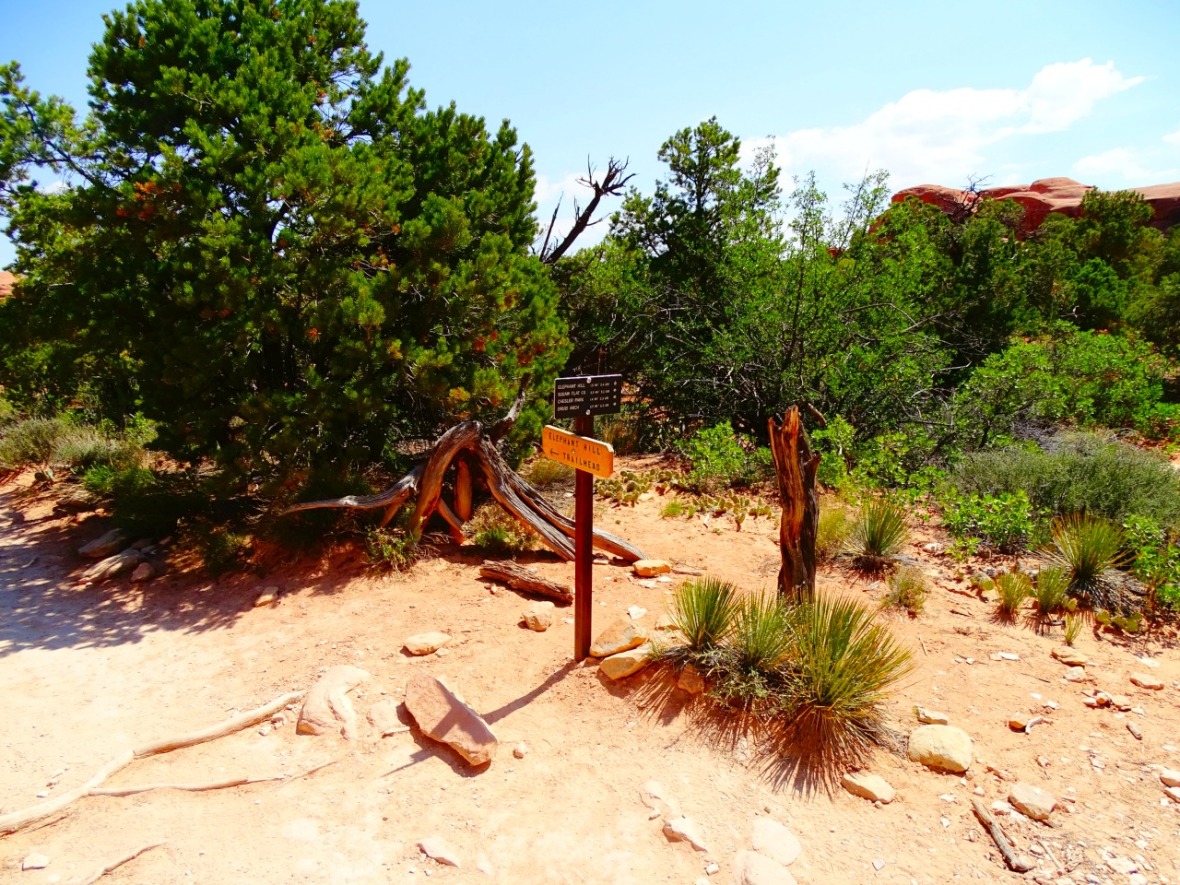
It starts at the Elephant Hill Trail Head. You end up on quite a few trails so make sure to bring a map to keep on the right path (see below). There is never a dull moment on this trail and don’t forget the elevation change. It was quite warm when we started but we ignored it because of the beautiful rock formations.

Aside from that the trail was easy at this point, but at times there wasn’t an actual trail. Throughout the hike you will have to look for the cairns that people have put out. It is especially important on the way back.
")
")
")
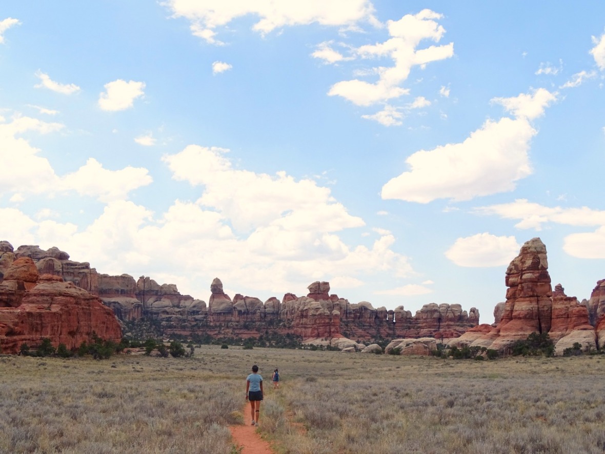
The beautiful red rocks and formations will have you distracted. It’s like nothing we had ever seen before and it only gets better from here.
")
")
After 1.5 miles comes the first trail marker.
At this point head to the right along the rocks and do not go towards Druid Arch (you can add Druid Arch onto the hike if you want. It is an out and back, if you have time). You will have to follow the cairns here and they will take you to your first slot canyon.


The dark rock kept it mysterious but it was a welcome spot to cool down from the hot sun. We were still doing good, but the heat was slowly getting to us. We didn’t think it was too bad so we continued on. It’s a desert, but we were not thinking of that, especially when you are walking through a slot canyon. The slot canyon is short, so you are right back in the hot sun.

The next marker comes up at 2.1 miles at a dried up river bed. Just walk on through and stay on the trail. There is a campsite to the right and a trail to the left, but you continue forward towards Chesler Park.

This is wear the trail really starts to climb and when you will start to really notice the sun. I was slowing down and struggling a little, but we were already this far in and again, I didn’t want to turn around.

For a moment the trail evens outs and you get back into a groove, but don’t let that fool you, the climb in that heat takes a lot out of you. We didn’t get any pictures because I was really struggling at this point. We climbed to the top where you have views on both sides and some shade. I had to stop and sit and eat one of the apples that we brought. Kevin still seemed fine and still I was stubborn and didn’t want to turn back. It seemed like we had hit the hardest part of the trail and so I continued on.
Up and over the rocks you reach Chesler Park. You can go either way, but we chose to go left on the Joint Trail and it was a good decision because the trail is easy to follow and flat! We got really lucky because we got some cloud coverage and so I felt back to my normal self.

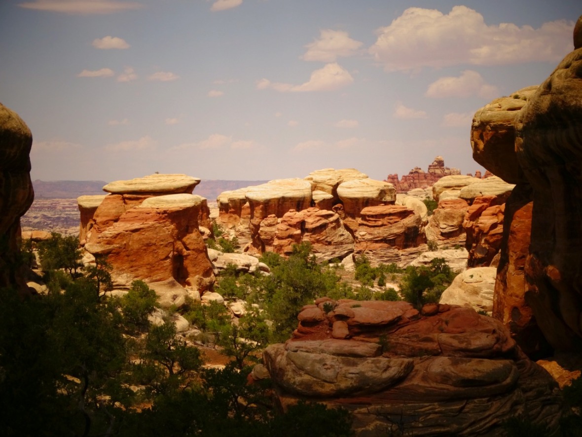
The trail is a bit dusty at first, but then the trail becomes compact. This area was awesome! Passing a couple back country camping spots, you walk along the amazing red and white banded rock pinnacles that you are waiting to see. They look like a lot of mushrooms lining the park. This would be a beautiful place to camp and to get some pictures of the stars or milky way!

This view was a 360 degree view. We spent quite awhile here taking pictures and enjoying the shade from the sun and the flat trail. This was actually the busiest part, we saw about 5 different groups here. This was surprising since we thought that we were getting a really late start for an 11 mile hike.

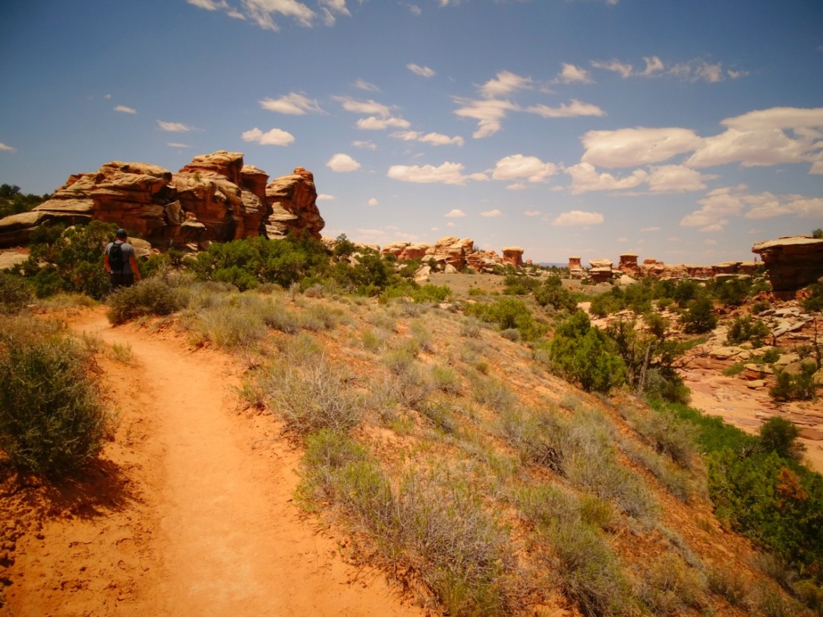
I knew that the slot canyon I really wanted to find was coming up soon. After a mile and a half or so the entrance appears. Ever so slightly, you can barely see it until you are taking your first step. in. A couple hikers walked right by it so follow the cairns and keep your eyes open!
")
")
")
")
")
")
There are two sections of this long slot canyon. We were giddy with excitement. We love wandering through slots. I used to think I would feel claustrophobic but I never have. I again appreciated the cool that came from being surrounded by the tall rocks and just when we thought it was over, the second small area to walk through appeared.
")
")
This is the half way point to the hike as a whole. You can either go back or continue on towards the road. We were hot, but we couldn’t decide which way to go. It was 5.5 back either way so we decided to take the loop and not back track. The easier way would have been to turn around and go back through the slot canyon.
This area may be busy because jeep tours are able to bring people here. Make your way to the a parking lot and go to the right. There is no shade and it is hot with the beating hot sun. Stay on the road.

Keep to the right and do not leave the road until you see a sign. There are cairns along the way, but I don’t know what they are for. So to make sure that you do not go out of your way, stay on the road until there is an actual sign. I am sorry there are no pictures of this sign. I was not doing good at this point in time and so we were just happy to find the sign because we thought we had missed something.
The trail is hard to find on the way back to the beginning of Chesler Park. You have to follow the cairns and there is little shade and a lot of walking on rock. We had to stop multiple times and this is when we ate our last apple and we only had a little water left to make it another 4 miles. We finally saw another couple who was better prepared but still struggling in the heat. The views were breathtaking though and so we stopped for a picture.

We got back to the Chesler Park sign (at least it starts the down hill part of this) and started heading towards Elephant Hill. We had three miles to go but it felt like an eternity. I could barely walk, the heat was weighing me down and we now had no water. I had to stop about ever quarter mile whenever there was shade. At 2.5 miles we had to stop and help people who were lost trying to find one of the camping spots. That slowed us down again and kept us in the heat. I finally had to stop. Kevin was still doing well and so we made the decision that he should go ahead and get the water in the car. Now, we know that this might not be by the book, but I needed water and the trail now, for some reason, had a slow but steady flow of people. I was not hallucinating or passing/blacking out and my body felt good. I was just HOT. I continued to move when I could and stopped when I needed and with about .75 miles left Kevin came with an umbrella and water. That’s all it took and we were back in the car and headed home.
We definitely learned a lesson here and since then I have been overly cautious. Of course, if I could go back I would change a lot but I can’t. It shows that even people that hike a lot and in multiple conditions can make mistakes or not be prepared. So please, make sure to either be very prepared or do not do the entire hike. It was incredibly beautiful and at any point it would have been fine to turn around and call it a great trail.
Packing List for Trail
Must have: Water (each person needs to carry their own water), sun block, a hat, snacks and map.
Map: The trail map that was provided by the national park did help, but it did not give distance to each point. We used this one and it helped. A LOT!
![20170604_141542[1]](https://33andfreedotlive.files.wordpress.com/2017/06/20170604_1415421.jpg?w=1180)
Optional: Knife, hiking poles, compass, gps monitor, lip balm. The couple that had gotten lost had a gps monitor on them. They ended up using the map above and our help to find the campground.
Of course: A way to take pictures!
Getting to Elephant Hill to hike Chesler Park Loop Trail
Chesler Park is in the Needles District of Canyonlands National Park. The trail head is at Elephant Hill. Find your way to Soda Springs and drive the 3 miles on a single lane gravel road with blind corners. There is plenty of parking at Elephant Hill Trail Head. This is also where the Elephant Jeep Trail starts, which is the road that you walk on for a short time. You need a permit for the road but you do not need a permit for the hike. We got a little confused for a second, but confirmed no permit for the hike.
Coordinates to parking: 38.141580, -109.827326
We hope that you get to explore this hike and area some day, but just in better conditions!
Love to pin, use this one!


This is beautiful!, I’m starting to think I need to move out West so I can have nice hiking scenery.
LikeLike
Nice report. Glad you made it out. Little mistakes can compound into bigger ones. Can be scary.
LikeLike
By your photos I can see how easy it would be to keep going. A great writeup showing not only the area but just how easy it is to get into trouble during the summer when the temps and sunshine are hot. I love your trip write-ups.
LikeLiked by 1 person
Thank you so much!
LikeLike