When we decided to stay in Northern Georgia for a week, the Appalachian Trail was our priority. This was the closest we had ever been to the trail and it was, of course, on our bucket list. We had already hiked parts of the Pacific Crest Trail and John Muir Trail and so the only thing to complete the trifecta…the Appalachian Trail! We read about the thru hikers and endurance runners and have always dreamed of just doing a part of it and we got our chance!
Hiking the Appalachian Trail to Blood Mountain
Total miles: 6 ♦ Trail: Hard ♦ Elevation: 1,400’+ ♦ Trail Type: Lollipop Loop ♦ Fact: Blood Mountain’s peak is the highest point of the Appalachian Trail in Georgia
Lucky for us, the highest point of the Appalachian Trail in Georgia was an easy 30 minute drive from where we were staying in Hiawassee. Normally a very busy part of the trail, for us it was quiet and only a few groups and solos. Everyone was nice and loved talking about hiking! We didn’t meet any thru hikers, but a lot of sectional hikers.
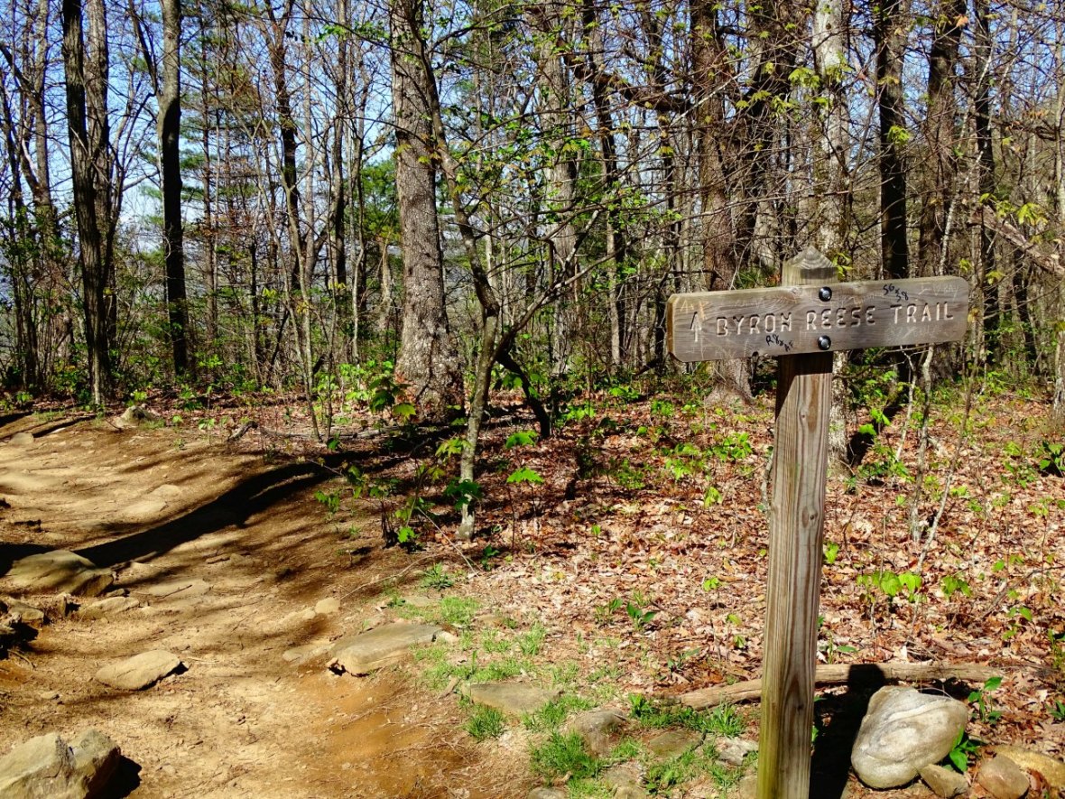
There are multiple places to park to catch the trail but we wanted to do this specific loop. We parked at the Byron Herbert Reece Memorial, which is the beginning of Byron Reese Trail. More information here: Parking
It’s a steady up hill .7 miles to the convergence of 3 trails. Byron Reese Trail, Freeman Trail and the Appalachian Trail.

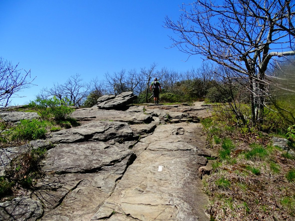
The first two are marked with signs, to follow the Appalachian Trail take a right and follow the white blazes (left will take you to Flatrock Gap via the Appalachian Trail and forward will take you on Freeman Trail with blue blazes). Sometimes the white blazes are on trees and other times they are on the rocks below your feet. Always easy to see.

After this point the switchbacks start and the elevation really intensifies. It’s usually around this point where I am like, “what the heck did I get myself into?” “Why do I like doing these hikes?” My thighs are burning and we are only just over a mile in. The 1,400′ of elevation gain was challenging but we are always happy at the end. The mental challenge and physical challenge makes the reward at the top all that much better.
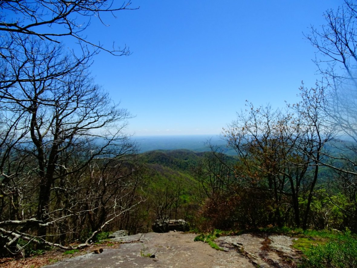
The first look out point is around 1.6 miles and even this early in the year it was beautiful. I can’t imagine the beauty later in the spring or the fall with all the colors.
Around here is when it got really rocky, small rocks, large rocks, huge boulders.
But just shortly after this vista point and around 2.1 miles in, you reach the cabin and the highest point on the Appalachian Trail in Georgia! Don’t forget to sign the log and read some of the fun things people have written. This was one of the cleanest cabins we have seen on remote hikes. We were surprised, especially since this is such a popular part of the Appalachian Trail.

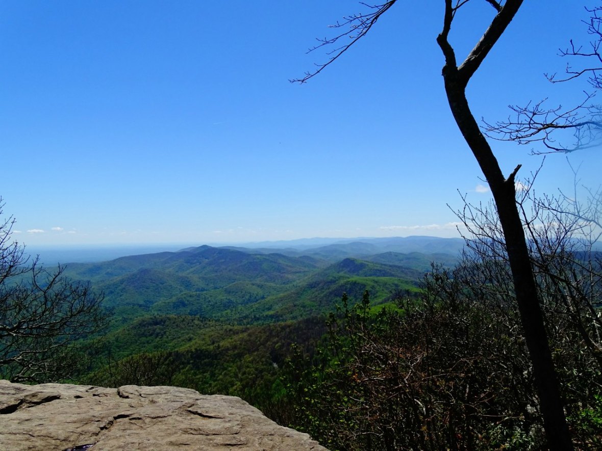
However, you can climb up a couple boulders to get a little higher and see a massive view!

It’s such an amazing feeling to reach your destination on one of these climbing hikes. I usually tell myself this is the last time, but the views really get me. It’s like a tattoo. It hurts during but then a couple days later you are figuring out what’s next. It’s an instant reward for your hard work (nothing else can get you to this point, but yourself), plus we get to do it with Summit and Ramey!
When you are done resting, snacking, chatting with hikers and taking in the views, you can of course head back the steep way back and make it a 4 mile hike, otherwise, you can take a steadier decline with Freeman Trail for a total of 6.
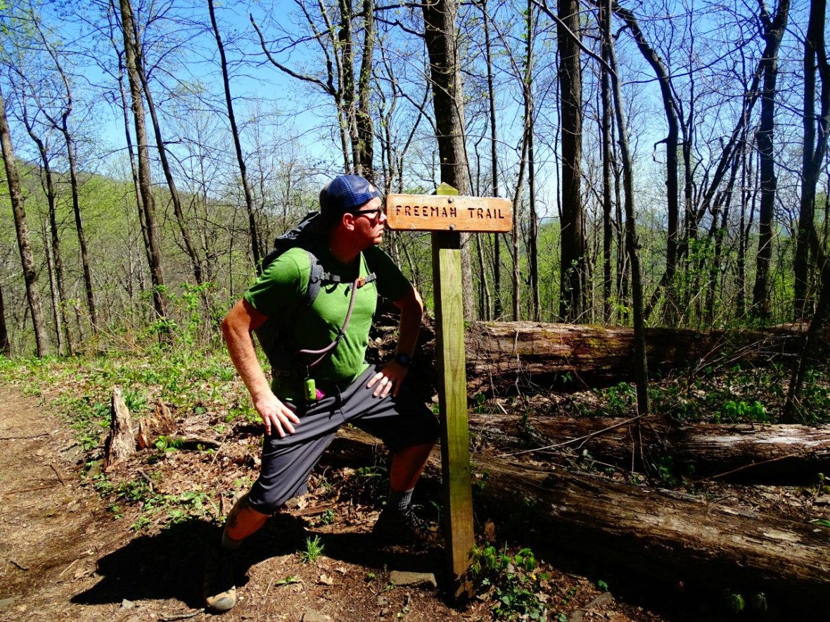
As you leave the cabin just keep head towards the sign that says “privy” if you want to make the trail the lollipop loop. I suggest this if you want to take some stress off the knees going downhill. It’s more gradual and definitely still beautiful. Make sure you are on the lookout for a left turn at the Freeman Trail sign, otherwise, you could go pretty far out of your way! Remember the Freeman Trail has blue blazes on the threes to follow.
This trail was definitely easier on the knees and more gradual than if you would have turned around. It’s a beautiful walk through the woods and a couple water stops to fill your bottle (only if you have something to clean or filter it with). After a mile or so it becomes pretty rocky, but still an easy hike. Just after five total miles you arrive back at the convergence. Make sure to stay straight on the Byron Reese Trail and not turn back on to the Appalachian Trail!
Just the last few switchbacks and you are back at the parking lot. We were happy as could be!
![20170425_165858[1]](https://33andfree.live/wp-content/uploads/2017/04/20170425_1658581.jpg?w=1180)
Tips before you go:
Bring water and snacks.
There are water spots along the way for the dogs, but I would suggest bringing some extra and a bowl for them. A couple snacks too and remember to keep them on a leash (it was slightly doggie busy) and pick up after them.
Bring a hat or some coverage as most of the trail isn’t covered from the sun.
Bring your polls if you are used to them, they will help.
Wear hiking boots or something with grip to help with the rocks, especially if it is spring and still a bit wet.
There is a lot of parking. The lot is a loop, so if the first area is full, you might find something farther along. If it is full do not park there and create your own spot. There is a sign that will tell you other locations that you can pick up the trail.
Optional packing items: knife, sun screen, compass, medical kit. Take a screen shot of the map if you need on your phone.
Lastly, PLEASE LEAVE NO TRACE. PACK OUT whatever you PACK IN!
Love to pin? Use this one!


Wow, these mountains look so majestic! What a way to spend a day!
LikeLiked by 1 person
Yep – have read a lot about these trails and it looks spectacular. I’d love, one day, to take a (admittedly gentle) hike in these mountains.
LikeLiked by 1 person
Now this sounds like a great hike! I’d love to hike portions both the Appalachian Trail and PCT! But you’re right sometimes I’m moaning on the way up but as soon as I see those views I quiet and soak it all in, knowing I will do it again and again!
LikeLiked by 1 person
Oh that’s a good goal to hike towards & happy to hear you made it! I feel exactly the same way as you when hiking – I hate it at the time & wonder what I’m doing to myself, but it always feels rewarding at the end. I’ve never heard it compared to getting a tattoo, it is the pain that puts me off getting one but maybe I should be looking at it in a different way, cheers 🙂
LikeLiked by 1 person
Oh wow – those views. Yo really get a feel for what an extensive range of mountains that is. And how beautiful!
LikeLiked by 1 person
Cute pups! I’ve hiked parts of the Pacific Coast Trail and the John Muir Trail. Now you’ve inspired me to complete the trifecta 😉
LikeLiked by 1 person
I hope you do! Its beautiful and we met some awesome people on it!
LikeLiked by 1 person
What beautiful views! I’m glad the hike was worth it, I suffer with my knees but when there’s a view like that at the end it really helps to keep me moving!
LikeLiked by 1 person
The US never ceases to surprise me! It has so many cool things to see and do! This one looks like and an amazing trail.
LikeLiked by 1 person