Updated: June 29, 2020
When we first started this blog, my hope was to inspire others to get outdoors more. For some it’s easy, they love the outdoors and can go on any hike they please. For them, I would love to show more places that they should explore. For others, getting outside can be daunting, scary even. For them, I wanted to show that there are places that are not hard to get to or hard to complete. You can experience the same amount of beauty and awe from a short hike.
Bend, Oregon is an amazing place for outdoor enthusiasts and people who are wanting to be outside more. The culture is play first, work second. Have a life, balance life, enjoy life. You don’t come here to just work. People are always outside. Last year when they had the worst snow fall in 20 years, that did not deter people. They found ways to embrace it, like cross country skiing to work, or getting fat tire bikes. During the hottest summer, you still find people in the mountains, running or biking or enjoying the river (there is a spot to surf!). It’s hard to meet people that don’t love the outdoors here.
Yes, a lot of the most popular hikes are long or hard, but this area has so much that anybody can do and it’s still BEAUTIFUL. There is really a hike here for anyone, at any skill level. Hiking in Bend, Oregon really is for everyone (including your fur friends!). With a river running through and views of mountains to the west, it will help you fall in love with nature. I may stray a little from the area, but how could I not with so many beautiful areas close by. Sisters, Sunriver, Terrebonne, to name a few.
This post is going to be the first part of a three part series of hiking in Bend. Hikes for Everyone in Bend, Oregon [Part 1], Moderate Hikes in Bend, Oregon [Part 2] and Hard Hikes in Bend, Oregon [Part 3].
So this post, as promised is focused on easy hikes in Bend, Oregon that are no more than 4 miles and rated as easy.
Benham Falls
When you are looking for a quiet hike, in what feels like the middle of nowhere, this is your place. Flat the entire way, with only a slight decline to a view point to see the falls, this hike is beautiful the entire way. You first cross over a bridge and then start the walk down what feels like a grand hallway. Except, instead of walls, you have huge trees lining the way. Then sounds of the running river and the smell of fresh air. This is definitely the easiest hike to a beautiful waterfall.

Distance: 1.5 miles R/T
Elevation Gain: 40′
Trail Type: Out and Back
Dog Friendly: Yes, on a leash
Family Friendly: Yes, very
Parking: Small parking lot with bathrooms and picnic tables – 43.931174, -121.413451
Parking Fee: May 1-September 30 $5/vehicle/day
Parking Accepted Passes: Northwest Forest Pass, Interagency Annual Pass, Interagency Senior Pass, Interagency Access Pass, Interagency Military Pass, Every Kid in a Park Pass or Northwest Forest ePass.
Trailhead: Benham Falls East Trailhead – 43.930255, -121.411997
Best Time: All year
Distance from Bend: 15 miles
Distance from Sunriver: 9 miles
Forest: Deschutes National Forest
Other Uses: Biking, Fishing, Birding, Trail Running, Picnicking
Access: Roads open year round, smooth roads.
USDA Website for Area Status: Benham Falls East Day Use/Trailhead
Todd Lake
The best time for this casual hike around a beautiful lake with views of the mountains is summer and fall. The road is closed in the winter and come spring it’s wet and muddy. You have a short walk form where you have to park, which is a gradual incline, but then a flat walk around the entire lake. It is over 20 miles from Bend, but it might as well be 100. You feel like you are nowhere close to civilization, there couldn’t possibly be a soul nearby. We were lucky enough to have the place to ourselves, it’s a place where we can keep coming back to and it will never get old.

Distance: 2 miles
Elevation Gain: 70′
Trail Type: Loop
Dog Friendly: Yes, on a leash from July 15 to September 15
Family Friendly: Yes, very
Parking: Small parking area – 44.023326, -121.682263
Parking Fee: May 1-September 30 $5/vehicle/day
Parking Accepted Passes: Northwest Forest Pass, Interagency Annual Pass, Interagency Senior Pass, Interagency Access Pass, Interagency Military Pass, Every Kid in a Park Pass or Northwest Forest ePass.
Trailhead: 44.023587, -121.682187
Best Time: Summer and Fall
Distance from Bend: 23 miles
Distance from Sunriver: 21 miles
Forest: Deschutes National Forest
Other Uses: Fishing, Birding, Trail Running, Picnicking
Access: Road closed December-March, Road can be rough in areas.
USDA Website for Area Status: Todd Lake Day Use Area/Trailhead
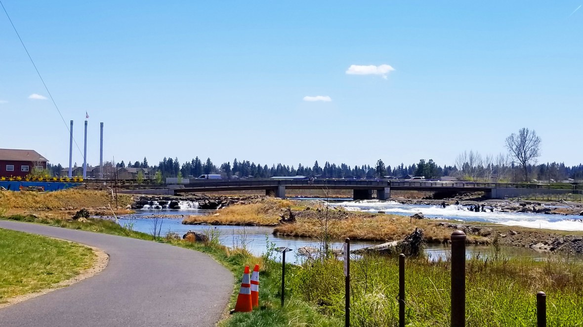
Deschutes River Trail
This trail is long and really is a tour of Bend. There are multiple places that you can pick it up for a different view of Bend. I am going to provide you with the two main areas. The entire path for both are not entirely flat, but easily accessible, ever so beautiful and close to town. Is that why people love Bend? Even close to town you feel you are outside of it. This is why I fell in love with it. You don’t have to go far to get a moment of peace. A moment’s view of the river, a peak at the mountains, getting lost in the forest. You can find that here.
Area 1 – Southwest Bend
This is a fun loop near the Old Mill District. With slight elevation, this 3 mile loop is right along the river. The turn around point is a bridge that provides a great spot for pictures.
Best place to park is: Farewell Bend Park: 44.040829, -121.324008
Area 2 – Northwest Bend
Get a different view of Bend. Depending on where you pick up this path, you can walk along the river, past a golf course and then see the river from above. Watch the more adventurous kayakers and cyclocross riders. On a clear day, you can see the mountains!

Thank you @teamburho for the picture!
There are multiple places to pick up this trail. There are a few spots of elevation and depending on where you park you will have to walk down a street, cross it and pick up the trail again.
Parking Options:
First Street Rapids Park: 44.067487, -121.313761
Random Parking Lot: 44.078454, -121.310627
Sawyer Park: 44.086351, -121.310443
Boyd Cave
Other than one staircase, the only thing that can hold you back is your fear of the dark and enclosed areas. After you get past the light that gets in, you’re in the dark! It’s quite the experience and can make for a fun time.
![IMG_20171204_192818_791[1]](https://33andfree.live/wp-content/uploads/2017/12/img_20171204_192818_7911.jpg?w=384&h=480)
Distance: 1 mile R/T
Elevation Gain: 0″
Trail Type: Out and Back
Dog Friendly: I wouldn’t bring them down into it.
Family Friendly: Yes, very
Parking: Small parking area – 43.941986, -121.197966
Parking Fee: No Fee
Parking Accepted Passes: N/A
Trailhead: 43.942213, -121.198375
Best Time: Year Round
Distance from Bend: 13 miles
Forest: Deschutes National Forest
Other Uses: Hiking, Caving
Access: Road open all year.
USDA Website for Area Status: Boyd Cave
Tip: Make sure to bring a headlamp, flashlight or something with light!
Hidden Forest
I was so determined to find this place. Seeing pictures online and through instagram had me mesmerized. It was slightly difficult to find it, but worth the search and confusion. There are other caves in the area and it’s a generally nice place to explore. Good for kids and dogs! A little tip and hopefully I remembered this right. Continue straight on the road (walking), when the split comes up go left, but it’s only for like 5′ and then you will see a small path on your right. Take that and then you will hit what feels like a road, but it’s a wide path. Just keep going straight and you will see where it looks like the ground caved in and you’ve found it!

Distance: 1 mile R/T
Elevation Gain: 0″ There is a decent to the cave, but not difficult.
Trail Type: Out and Back
Dog Friendly: Yes
Family Friendly: Yes, very
Parking: Small parking area – 43.905868, -121.159069
Parking Fee: No Fee
Parking Accepted Passes: N/A
Trailhead: 43.905638, -121.159407
Best Time: Year Round
Distance from Bend: 18 miles
Forest: Deschutes National Forest
Other Uses: Hiking, running, caving, biking
Access: Road open all year.
USDA Website for Area Status: N/A
Tumalo Falls
One of the must see places in Bend. This area is lucky to have something this beautiful right at the parking lot. If you can go further the area will put on a show for you. Multiple waterfalls, swimming spots, beautiful trees and a great trail. This is the start to an amazing hike or mountain bike loop. You really can’t ask for anything more.

Distance: .5 miles R/T to the top of the waterfall. You can continue on if you would like.
Elevation Gain: 95′
Trail Type: Out and Back
Dog Friendly: Yes, on a leash
Family Friendly: Yes, very
Parking: 44.031853, -121.566435 (One toilet)
Parking Fee: May 1-September 30 $5/vehicle/day
Parking Accepted Passes: Northwest Forest Pass, Interagency Annual Pass, Interagency Senior Pass, Interagency Access Pass, Interagency Military Pass, Every Kid in a Park Pass or Northwest Forest ePass.
Trailhead: 44.032013, -121.566371
Best Time: Spring, Summer, Fall. Note in the winter, the road is gated and it becomes a 6 mile hike R/T to the falls.
Distance from Bend: 13 miles
Forest: Deschutes National Forest
Other Uses: Trail Running and Mountain Biking (uphill only)
Access: Road closed December-March (?)
USDA Website for Area Status: Tumalo Falls Day Use Area
Shevlin Park
There are a lot of options here. You can either take a paved forest road (no cars allowed) through the forest, or a groomed path along the river or a slightly elevated path that is higher up for the views below. The elevation for a hike is ever so slight. Your pups and/or kids will love this area. In the summer, make sure to watch out for mountain bikes finishing a long ride from Tumalo (above). If you are feeling good, you can continue on, the possibilities are endless. I love running in this area. You really do have options and it’s so close to town.
![IMG_20171207_213127_898[1]](https://33andfree.live/wp-content/uploads/2017/12/img_20171207_213127_8981.jpg?w=1180)
Distance: 4 miles R/T
Elevation Gain: 70′
Trail Type: Out and Back
Dog Friendly: Yes, on a leash
Family Friendly: Yes, very
Parking: There are three small lots – 44.083335, -121.377876, 44.083543, -121.377463 and 44.081740, -121.378595
Parking Fee: Free
Parking Accepted Passes: N/A
Trailhead: The groomed trail starts near the parking lot – 44.083335, -121.377876, the paved forest road, starts past the second parking lot – 44.083335, -121.377876
Best Time: All Year
Distance from Bend: It’s only 3 miles from Downtown.
Forest: N/A
Other Uses: Mountain Biking, Running, fishing, picnicking.
Access: All Year Long
Website for Area Status: Shevlin Park
River Trail
In case you are in need of a paved path, the Old Mill loops are great. These loops are flat and give you access to so much. Deschutes River Trail, Old Mill District, Les Schwab Amphitheater, dog parks, surfing, river access, volleyball and so much more. They are well maintained, but you do have to be careful of geese and ducks (and their droppings!). This is private land so before you try and explore every bit of shoreline, make sure to read posted signs.
There are multiple places to park to pick up this paved path.
Miller Landing Park: 44.051825, -121.321660
McKay Park (street parking): 44.049768, -121.322081
Old Mill District: 44.048045, -121.314659
Riverbend Park: 44.042643, -121.318813
Farewell Bend Park: 44.040829, -121.324008
Steelhead Falls Trail
This trail is short and beautiful and the first part is all downhill, it’s the second part and your way back to the car that is a little more difficult. It’s a straight incline, around 225′ in one mile. In the summer it provides an awesome swim hole and picnic area to have a view of the waterfalls. Just take it slow on the way back if you are new to hiking. In the winter, this trail is not maintained and can be a bit more tricky. I would say if you are new to hiking, do not come in the winter. If you love snow shoeing, this is a favorite for some. You might get lost for just a second, or if there is no trail in the winter, wonder which way to go. Just make sure when you come to the ridge, looking at the river, that you head right, with the river on your left. This is also a bit farther from Bend, but is worth a day trip!

Distance: 2 miles R/T
Elevation Gain: 225′
Trail Type: Out and Back
Dog Friendly: Yes, on a leash
Family Friendly: Yes, very
Parking: 44.411012, -121.292551
Parking Fee: Free
Parking Accepted Passes: N/A
Trailhead: 44.411289, -121.292631
Best Time: All Year
Distance from Bend: 33 miles
Distance from Terrebonne: 9.5 miles
Forest: N/A – This is considered BLM (Bureau of Land Management) land and is maintained by the US Department of the Interior.
Other Uses: Fishing, picnicking, swimming, camping
Access: All Year Long
Website for Area Status: Steelhead Falls Trail
Cline Falls

Close to Ben and even closer to Redmond, this easy one mile round trip hike is dog and family friendly. Starting at Cline State Park, it’s an easy half mile to the view point for the falls. With only 49′ in elevation gain the entire mile, it’s great for everyone. The waterfall was a pleasant surprise. It is amazing the water features that we have close by and all while being in the desert. Easy enough to picnic or take a snack and enjoy your surroundings. I highly suggest parking in the state park’s parking lot and not along the highway. The trailhead can be slightly hard to find. If you park in the parking lot, head back on the road you came in and you will see the path on your left. It heads down towards the river, so be on the look out.
Distance: 1 miles R/T
Elevation Gain: 49′
Trail Type: Out and Back
Dog Friendly: Yes, on a leash
Family Friendly: Yes, very
Parking: 44.268800, -121.255714
Parking Fee: N/A
Parking Accepted Passes: Oreg
Trailhead: 44.411289, -121.292631
Best Time: All Year
Distance from Bend: 19.5
Distance from Redmond: 4.6 miles
Other Uses: Fishing, picnicking, swimming
Access: All Year Long – Day Use Only
Family Friendly Hikes Near Bend, Oregon
In addition to hikes in Bend, there are so many family friendly hikes near by. Here are a few and as always this is always being updated.
Newberry National Volcanic Monument

Picture by Just Go Travel Studios
This monument and nearby area offers a unique experience. The rocks from lava flow create a beautiful background. There is more here than meets the eye and we are grateful for Just Go Travel Studios for creating such an in-depth post about it: Newberry National Volcanic Monument
West Metolius Trail
Only about 45 minutes from downtown Bend, Oregon, West Metolius Trail is great for families, fur friends and any skill level. It’s a beautiful hike along the river and through the woods. You can either start at the Fish Hatchery or Lower Canyon Creek Campground. Roundtrip it is a 5 mile hike with very little elevation. You will see the bluest of clear water and a small waterfall . While the waterfall is not mighty, it is beautiful and a great spot to sit for lunch or a snack.

Hiking Tips and Etiquette!!
Just a few points before you go, whether you are new to hiking and nature or a veteran; Always Remember:
The first and main tip I can give for anyone who travels here that does not live at elevation, you may feel it. Especially during the summer. Make sure to bring water and understand your limits.
Take pictures, leave footprints – In some areas, stay on the trail. Even a footprint can create damage.
Dog waste – Please ALWAYS pick up after your dog and take it with you. Don’t leave the bag for someone else.
Campfires – Check before you decide to light up. Fire bans, or distance from water must be abided by. We are in someone else’s home, and we must respect that. After the fires of 2017, please put out all fires 100%.
Nature – Do not cut, damage, gather or litter. I don’t need to know you were there on a date by slicing into a tree, nor does a rock care that you heart someone. Take a picture for your memory to put on social media. Nature isn’t a social media platform.
Always Updating
I will always be updating this post as we learn of new hikes. Two hikes to look forward to are:
Lucky Lake Trail
Three Creek Lake Trail
So make sure to follow along, so you don’t missed one and let me know of your favorites!
Love to Pin, use this one!


Nice list with clear descriptions. Thank you!
LikeLiked by 1 person
I love this! I actually just posted trail runs for everyone in Bend 🙂 I just moved away from Bend and already miss it so much. It is such a magical place!
LikeLike
Thank you! I checked out your article. Long runs. I liked it!
LikeLiked by 1 person
Thanks! Bend is such a great place to hike or run 🙂
LikeLike