We were introduced to Natural Bridges National Monument about 4 days before we went there. This was the perfect start to our Utah adventure. Hiking in Natural Bridges National Monument with friends, history and exploring a new place!
Established: April 16, 1908 ♦ Area: 7,636 acres ♦ Elevation of National Monument: 6,500′ ♦ President: Theodore Roosevelt ♦ Fun Fact: It’s Utah’s first National Monument
The natural bridges are on their third round of names.
- President, Senator and Congressman
- Augusta, Caroline and Edwin
- (current) Hopi names: Sipapu, Kachina, and Owachomo
Hike 19/52 in the Challenge
The hikes to each of the three bridges was short and done separately but on the same day we decided to combine them as one hike for the challenge.
Hiking in Natural Bridges National Monument
Before you get to hiking in Natural Bridges National Monument, start your day at the visitor’s center. There is a small fee unless you have one of the national park passes. This small fee will give you access to the loop that has all the trail heads for the bridges. The parking lot is great for anyone towing as they have a location for you to drop your rig or trailer before heading out on the loop. There is parking at each trail head but I wouldn’t recommend towing in if you are longer than 20′. There are a couple spots for larger vehicles but most don’t seem to care and park there anyways, so no guarantees. There is a small shop, restrooms and a small museum at the visitor center.
Sipapu Natural Bridge
Sipapu means “place of emergence.”
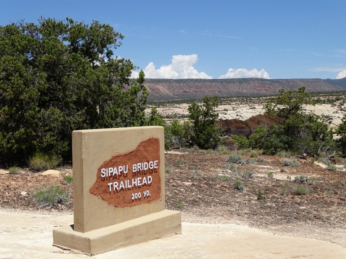
The first natural bridge you come to is Sipapu Bridge. This natural bridge is the second largest in the world, only after Rainbow Bridge in Glen Canyon (just down the road). Hiking to this beautiful natural bridge is the hardest to get to. Multiple steps and ladders down to the canyon floor. If you are not used to the elevation make sure to take your time. This national monument sits at 6,500′, well above most people’s comfort. At the end you are rewarded with the beauty of Sipapu Bridge.
This was the best hike of the three. It had a couple beautiful vista points along the way as well as the fun with the ladders. Surprisingly there is a lot of foliage at the bottom. Trees, tall reeds and cacti. Be careful of the cacti, they are ankle level and sometimes hidden so stay on the trail!
Miles RT: 1.2 ♦ Elevation change: 500′ ♦ Difficulty: easy-moderate

")

")
")

Kachina Natural Bridge
The name Kachina came from the Kachina dancers that play an intricate roll in the Hopi people’s religion.
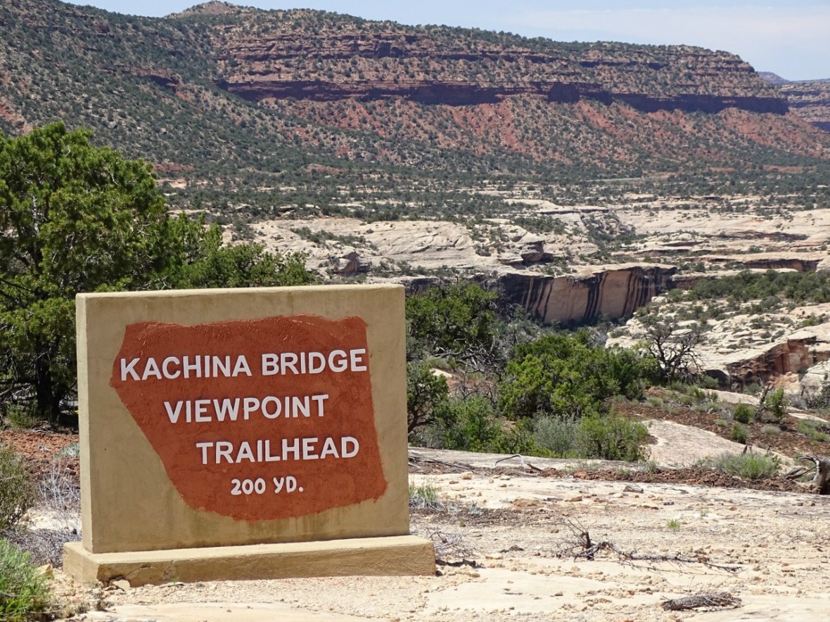
Driving a little further you reach Kachina Natural Bridge. This bridge is considered the youngest of the three because of the thickness of its span. Each bridge does have an overlook, but because of the thickness of this one you cannot see it very well from above. You will see quite a few large boulders at the bottom, this is from the most recent rock fall in 1992 when 4,000 tons of rock broke off. This was my favorite bridge to explore. Because of the thickness it felt unique, along with the entrance to the canyon and other large rock formations.
The high walls around the natural bridge hold an extra feature to appreciate. High above lies a granary. The walls and sticks used for the roof are still in tact. It’s a bit of a climb to see it but you can get right up to it.
There was a small amount of vandalism on the base of this bridge. I really don’t get it. I don’t care if your initials are BH or that L (hearts) M. No one really cares, you will never see it again and it doesn’t mean that you will be together forever. Respect these natural wonders that we are lucky to have.
Miles RT: 1.4 ♦ Elevation change: 400′ ♦ Difficulty: easy-moderate
")
")
")
![DSC06930[1]](https://i0.wp.com/33andfree.live/wp-content/uploads/2017/06/dsc069301.jpg?w=586&h=586&crop=1&ssl=1 "DSC06930[1]")
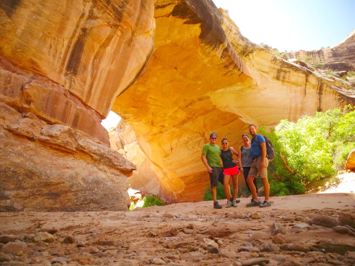
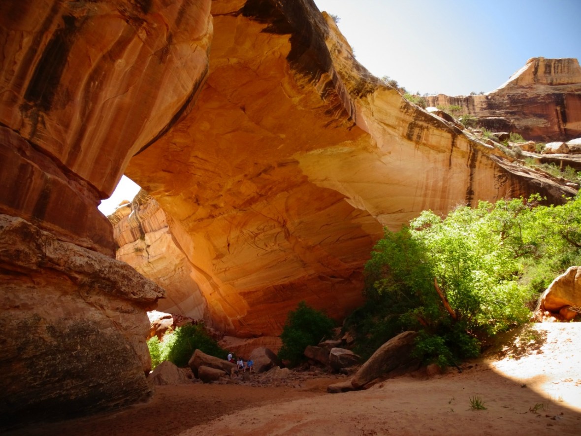
Owachomo Natural Bridge
Owachomo means “rock mount” in Hopi and they named it this because of the rock formation on the top of the bridge.

The third and final natural bridge is Owachomo Natural Bridge, which is the most popular. This hike is the easiest but still fun. At the base of the bridge there are some beautiful rock and just a little further down from the bridge there is a canyon with some water areas and great picture taking spots. We really enjoyed exploring this area. Unfortunately, because of the delicacy of this bridge, they think it is eroding more quickly so make sure to see it before another natural wonder is gone forever!
Miles RT: .4 ♦ Elevation change: 180′ ♦ Difficulty: easy


Other Hiking Options in Natural Bridges National Monument
Loop Trail. Instead of doing these as individual hikes you have multiple options to do looped hikes. There are loops that connect two bridges together as well.
Sipapu/Kachina – 5.6 miles
Kachina/Owachomo 5.4 miles
Loop Trail – 8.6 miles By doing these looped hikes if you have time, you will get to see more of the canyon that these natural bridges were formed in.
Horsecollar Ruin – This is located just after Sipapu Natural Bridge. It has it’s own parking lot, an overlook and a short .6 mile RT hike with only 30′ in elevation change. From the outlook you can see the remains of some Puebloan cliff dwellings. Granaries and a Kiva (ceremonial and meeting room) are also available to check out.
Know Before You Go To Natural Bridges National Monument
There isn’t a lot around here so bring food and water if you are making a full day of this national monument.
Dogs are ONLY allowed in parking areas and paved trails (which are just the overlooks). They are NOT allowed on any of the actual trails down to or the loop trails of the national bridges.
There are garbage cans at every trail head and some do have recycling cans. Please pack out whatever you pack in.
Getting to Natural Bridges National Monument
Now, this can be the fun part! We were staying in Valley of the Gods, just off of Valley of the Gods Rd. Because of our location we had a choice to make about how to get to the National Monument.
The short way: Heading north on 261 is the shortest distance from Mexican Hat. At only 45 miles, this is the way that most take. However, this way also includes the famous Moki Dugway. With a 10% grade, loose gravel, tight switchbacks and steep drop offs, it’s considered one of Utah’s most dangerous roads. With multiple warning signs before you get there, they do say that you should not tow or be over 10,000 lbs. I was hoping to avoid this, as my fear of heights has become, well let’s just say a fear. Our friends talked us into it considering we would have to go 40+ miles out of our way otherwise. I survived and it wasn’t as horrible as I thought, but still, it’s nothing to take lightly when driving.
It did provide us with some incredible views, of which I wasn’t able to look at for very long. It wasn’t any easier coming down, but I did appreciate not having a super long drive.


The long way: Head north on 163 and then merge onto 191 towards Blanding, UT. Then take 95 W and you will see the signs to the national monument.
Coordinates to the Visitor Center: 37.608909, -109.976280
If you are staying in the Mexican Hat, UT area make sure to drive Valley of the Gods Road. It is absolutely beautiful and a great place to camp!

On your way you will probably drive through Monument Valley if you are coming from the south. If not, definitely check it out. You can stand where Forrest Gump ran, see the insane rock formations and take in the beauty of the area.

Love to Pin? Use this one!


Amazing Kym and Kevin. Such beautiful parts of the country. I am really glad you are able to travel to those places. Be safe. Dad
LikeLiked by 2 people
What a stunning place! Beautiful photos. Thanks for sharing tips and information about the area.
LikeLiked by 1 person
Thank you! I hope that you get to it during your travels at some point!
LikeLiked by 1 person
Oh man, I should have gone there instead of Arches NP. I had my dog with me and I could not even visit the arches, because no dogs were allowed on the short walkways to the viewpoints from the parking lots. Monuments and state parks are usually much easier going on pets. Got to check this out next time!
LikeLiked by 1 person
Very true! Although, here you could only do the view points and not the actual trails, but still better than nothing!
LikeLike
Looks like a beautiful area with lovely views! Will definitely visit if I make it to Utah.
LikeLiked by 1 person
I’m used to wonderful pictures of yours when visiting your blog, but these natural bridges are just stunning. Some of them made me go back and look at them again. Amazing what nature can do, right! 🙂
LikeLiked by 1 person
Thank you! It amazes us every time!
LikeLiked by 1 person
Looks like you had a great time here. Natural bridges like these are my favorite. I will definitely plan to visit here one day.
LikeLiked by 1 person
Looks like a fantastic trip. I love your shots of Owachomo Natural Bridge, especially the last one.
LikeLike
The Dugway is a piece of cake! I lost track of how many times we did it when we were staying in the Valley of the Gods (OK, we did it twice). Brilliant drive!
LikeLiked by 1 person
Very jealous of that camping spot, but not jealous at all that you are towing that beast around! I’m perfectly happy with popping up a small tent out of the back of my car/hatchback and calling it a day. But hey, to each his own 🙂
I can understand why Owachomo is the most popular, your photos are incredible – it reminds me of a thicker version of Landscape Arch at Arches NP. Awesome pics, and thanks for sharing this info about another natural wonder in Utah… damn that place is a wonderland. I mean, in the natural beauty way.
LikeLike